state route ranger badge
Arizona
60

State of Arizona Parks

responsive menu icon
USA Parks
Arizona
Phoenix & Central Region
Find A Park
start slideshow
Picacho Peak State Park Picacho Peak © John Hunnicutt II
Taken of the south face during sunset with a little banner cloud hovering at the top.
Cabeza Prieta National Wildlife Refuge © Hollingsworth, John and Karen - U.S. Fish and Wildlife Service / Public domain, via Wikimedia Commons
View from Cabeza Prieta National Wildlife Refuge, Arizona 1
Picacho Peak State Park Picacho Peak © John Hunnicutt II
Taken of the south face during sunset with a little banner cloud hovering at the top.
Tonto National Forest Crooks Trail Overlook © George Bowers
This photo was taken at one of the numerous turnouts along the General Crook Trail also designated as SFR 300.
Lake Mead National Recreation Area © Joe Leavitt
Grand Canyon National Park © Dewese Milstead
Grand Canyon National Park Grand Canyon © Rafael Zhadanovskiy
November 2010, South Rim
Cactus Wren © stateparks.com
A species of wren that is native to the southwestern United States southwards to central Mexico.
Keep On Leash © stateparks.com
Spring Hike © stateparks.com
Afternoon Hike © stateparks.com
Search
Availability
Calendars
Availability Search
Arizona's Phoenix & Central Region Parks

1
National Monument
1
State Wildlife Area
2
State Parks
1
Metro and City Parks
Parks in this region are near these Arizona Cities (click city name to see parks within 25 miles)
CHANDLER
PHOENIX
GLENDALE
MESA
TEMPE
PEORIA
BUCKEYE
CASA GRANDE
GILBERT
QUEEN CREEK
SURPRISE
SCOTTSDALE
GOODYEAR
AVONDALE
SAN TAN VALLEY
LAVEEN
Arlington State Wildlife Area
The Arlington Wildlife Area AWA is located along the west bank of the Gila River approximately 3-1/2 miles south of Arlington and 15 miles southwest of Buckeye in Maricopa County, Arizona. AWA is approximately 1500 acres, being composed of lands owned by the Arizona Game and Fish Commission and lands ........more >
Casa Grande Ruins National Monument
Explore the mystery and complexity of an extended network of communities and irrigation canals. An Ancestral Sonoran Desert People's farming community and Great House are preserved at Casa Grande Ruins. Whether the Casa Grande was a gathering place for the Desert People or simply a waypoint marker in ........more >
Lost Dutchman State Park
Named after the fabled lost gold mine, Lost Dutchman State Park is located in the Sonoran Desert, 40 miles east of Phoenix. Several trails lead from the park into the Superstition Wilderness and surrounding Tonto National Forest. Take a stroll along the Native Plant Trail or hike the challenging Siphon ........more >
Papago Park
The trails in Papago Park offer the best and worst of city hiking. In the heart of the Valley, you have miles of trails that pass Hohokam ruins, statue-like rock formations and queues of panicking quails. You also have the drone of traffic on Loop 202, an endless stream of jets overhead, and desert ........more >
Picacho Peak State Park
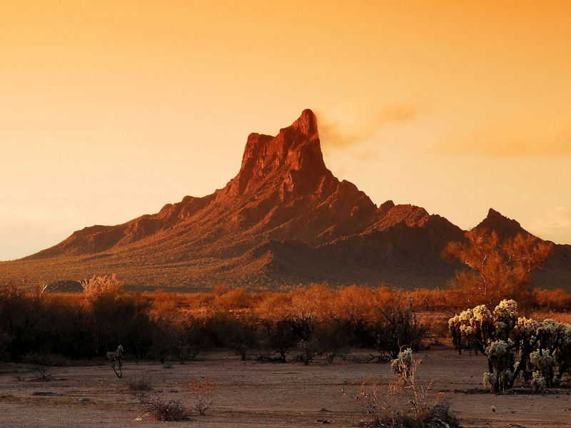
Visitors traveling along I-10 in southern Arizona cant miss the prominent 1,500-foot peak of Picacho Peak State Park. Enjoy the view as you hike the trails that wind up the peak and, often in the spring, overlook a sea of wildflowers. The park and surrounding area are known for its unique geological ........more >
Visit Another Arizona Region

state route ranger badge
Arizona
60

State of Arizona Parks

X